Gandikota Fort entry points: main gate versus western postern
The most common mistake at Gandikota Fort is to treat every opening in the fort wall as an entrance. They are not.
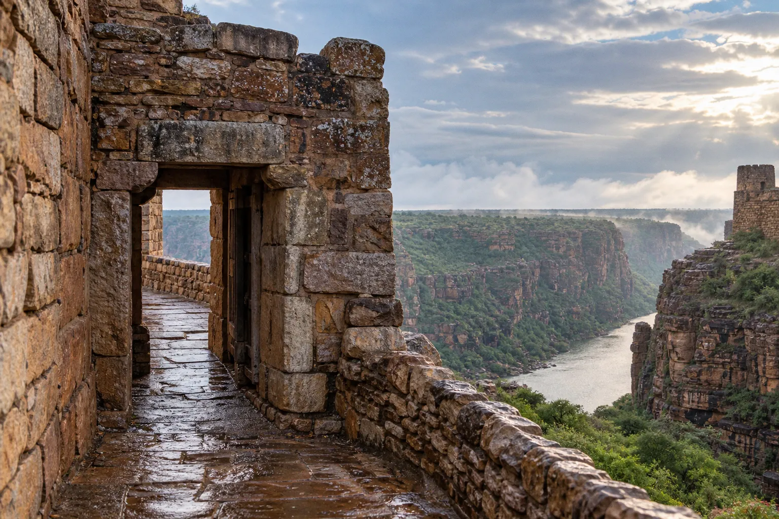
The eastern main gate is the practical access point for visitors, vehicles, and the first movement into the historic settlement, while the western edge is shaped less by a conventional gate than by the Pennar River gorge, steep cliff lines, and a perimeter that was designed to make approach difficult.
That distinction matters when planning gandikota fort entry points for historical exploration. If you arrive expecting to walk in through a clearly marked western postern, you may spend valuable daylight searching for an opening that is not established as a regular public entrance. If you enter from the east, however, the fort begins to explain itself almost immediately: the road narrows into a defensive approach, the gateway rises ahead, and the interior landmarks fall into a readable sequence from the Hanuman temple to the Nagarkhana and the wider ruins beyond.
The main gate is therefore both an entrance and an architectural argument. The western perimeter is something different—a landscape of walls, bastions, cliffs, and viewpoints that must be explored from within the fort or along established approaches rather than treated as a second front door.
The eastern main gate is the fort’s real point of arrival
Gandikota Fort’s primary entrance lies on the eastern side, where the approach passes through a defensive enclosure before reaching the principal gateway. The route does not run straight toward the interior. Instead, it bends through a zigzag pathway, forcing anyone approaching the fort to slow down, change direction, and expose themselves to observation from the surrounding walls.
For a visitor, this geometry is easy to miss if you are thinking only in terms of access. The road appears to be carrying you toward the village and ruins, but the alignment is doing historical work at every turn. A direct approach would have allowed an attacking force to gather momentum and bring pressure against the gate. The angled route breaks that movement. It creates a sequence of controlled spaces in which defenders could monitor, delay, and confront an advancing group.
The main entry gate itself is approximately 20 feet high, set between thick red granite or red sandstone walls. Its wooden doors were reinforced with iron spikes, a practical response to the use of war elephants against fortified entrances. The spikes were not decorative details added to make the gate appear more formidable; they belonged to a defensive system in which the material of the gate, the weight of its doors, the turning angle of the approach, and the height of the flanking walls all worked together.
At Gandikota, the entrance is not a line in the wall; it is a controlled sequence of turns, thresholds, and delays.
Once you stand near the gate, look back along the approach before walking inside. This reverse view makes the design clearer. From outside, the walls frame the passage and reduce the number of directions from which an intruder could move. From inside, the entrance becomes a funnel opening toward the eastern landscape, with the defensive enclosure functioning as a buffer between the fort’s interior and the road beyond.
Main gate versus western perimeter access
The two sides of Gandikota should not be approached as equivalent alternatives. One is a recognized arrival route; the other is primarily a rugged defensive edge and a landscape to be read on foot.
| Feature | Eastern main gate | Western perimeter paths |
|---|---|---|
| Visitor function | Primary pedestrian and vehicular access into the fort area | Informal or less-traveled exploration along the defensive edge |
| Architectural character | Zigzag approach, massive gate, flanking walls, reinforced doors | Bastions, curtain walls, cliff edges, and views across the gorge |
| Historical purpose | Controlled entry and defense against direct assault | Protection through elevation, fortification, and natural inaccessibility |
| Navigation | Relatively clear arrival sequence from road to gateway | Uneven, fragmented movement requiring orientation inside the complex |
| Public access status | Established main entrance for ordinary visitors | No confirmed dedicated western postern for regular tourist entry |
| Best use | Beginning a historical visit and understanding the fort’s defensive logic | Studying walls, bastions, sightlines, and the Pennar gorge landscape |
This is the essential answer to the main gate vs postern gate access question: the western side may contain routes, breaks, and defensive edges that resemble secondary access in a historical sense, but that does not make them an officially designated entrance today.
The western “postern” is better understood as a question than a doorway
A postern is usually a small secondary gate, often placed away from the main entrance and used for discreet movement, local access, communication, or emergency sorties. Forts across the subcontinent frequently contain such openings, and the idea of a western postern at Gandikota is plausible enough to attract attention. Yet plausibility is not the same as a confirmed, publicly accessible gate.
The western and northern sides of Gandikota are naturally protected by the Pennar River gorge, which cuts through the Erramala hills for approximately 4 kilometres and reaches a depth of around 700 metres in the canyon landscape. The gorge is not an ornamental backdrop behind the fort. It is one of the fort’s principal defensive structures, a difficult-to-cross edge that reduces the need for continuous conventional entry control along those faces.
This is why the western side feels different when you reach it. The wall does not stand in isolation from the terrain; it works with the terrain. A bastion projects toward the open space, the curtain wall follows the elevated ground, and beyond it the land falls away toward the river corridor. The resulting defensive line is partly masonry and partly topography.
There may be local descriptions of lesser openings or paths along the western perimeter, but there is no established basis for treating a dedicated western postern as the normal public entrance for vehicles or visitors. The safer and more accurate way to describe the route is as western perimeter access: movement along the fort’s edge, where conditions vary and where the historical value lies in the relationship between architecture and cliff, not in passing through a formal gate.
How to explore the western side without misreading it
Begin at the main eastern entrance and move through the fort rather than attempting to approach the western edge from outside. This gives you a continuous sense of the settlement and avoids turning a difficult cliffside route into an improvised entry attempt.
As you cross the complex, keep the following visual sequence in mind:
1. Use the main gate as your reference point. Its heavy walls and controlled approach provide the clearest fixed landmark in the fort.
2. Move inward toward the historic structures before turning toward the perimeter. The interior helps you understand which walls belong to the inhabited fort and which edges are primarily defensive.
3. Locate the broad western and northern views from inside the fort. The gorge should appear as a major spatial boundary, not merely as a viewpoint destination.
4. Follow visible, stable paths rather than cutting directly toward the cliff. The shortest line on a map may cross broken ground, loose stone, or an unprotected edge.
5. Treat every wall opening as an observation point unless its access is clearly established. A gap in masonry may be a collapsed section, a later break, or part of an old defensive arrangement—not a usable gate.
6. Return before light fades. The western perimeter has fewer obvious navigation cues once the interior landmarks and wall alignments become difficult to distinguish.
The difference between historical exploration and route improvisation is particularly important at a monument like Gandikota. The fort’s walls are old, and their visual continuity can be misleading: a section that appears to invite passage may lead toward a steep drop, a rough slope, or a fragment of wall with no safe continuation.
Walking the five-mile perimeter: read the walls as a strategic map
The fort’s perimeter wall extends for approximately 5 miles and is reinforced by 101 bastions, each rising more than 40 feet high. These numbers are useful not simply because they convey scale, but because they change the way you should walk through the site. Gandikota is not a compact enclosure that can be understood from one central courtyard. It is a long defensive landscape, and its logic emerges gradually as you move between interior ruins, wall walks, projecting bastions, and elevated views.
A bastion is a projecting structure built into or beside a fortification wall. In simple terms, it pushes outward from the main line of the wall so defenders could observe and protect areas that would otherwise remain hidden beneath the wall face. From the visitor’s perspective, a bastion often feels like a lookout. From the fort’s perspective, it is part of a connected field of vision.
As you walk, notice how the bastions intersect with the landscape:
- Some project toward open ground, where an approaching force would have been visible well before reaching the wall.
- Others align with bends in the perimeter, allowing defenders to observe sections that were not visible from a straight wall.
- Along the gorge, the bastions reinforce the psychological and practical effect of the cliff, marking the boundary between accessible ground and the natural drop.
- From elevated points, the wall’s route becomes easier to understand: it is not a perfect geometric enclosure, but a line shaped by terrain, settlement, and defensive need.
The best gandikota fort wall walking routes are therefore not necessarily the longest ones. A useful walk combines a section of the eastern fortification, the central historic structures, and the western or northern edge where the wall meets the gorge. This gives you three different readings of the monument: controlled entry, inhabited interior, and natural defense.
A practical route through the fort
A sensible historical circuit can be organized in five movements:
1. Approach the eastern gateway from outside. Pause before entering to study the zigzag route, the enclosure, and the way the gate is framed by thick masonry.
2. Pass through the gate and note the first interior landmarks. The Hanuman temple appears immediately beyond the main gateway, followed by the historic House of the Drums, or Nagarkhana.
3. Continue toward the principal ruins and temple structures. Here the fort shifts from a defensive threshold into a settlement with religious, administrative, and ceremonial spaces.
4. Turn toward the perimeter after establishing your interior bearings. Use the wall and bastions as a continuous line rather than wandering directly toward isolated viewpoints.
5. Finish at a stable gorge-facing position before retracing your route. The return journey is easier when you leave the western edge with enough daylight to recognize the same wall alignments and interior landmarks.
This circuit also prevents a common navigational error: starting at the most dramatic cliff view and then trying to reconstruct the fort from the edge inward. The gorge is visually dominant, but the main gate explains the monument’s organization more clearly. Begin with the entrance, then let the landscape widen around you.
From the Nagarkhana to the Hanuman temple: the first interior sequence
The space immediately inside the eastern gateway is important because it shows that the entrance was not an isolated military object. It was connected to the social and ceremonial life of the fort.
A small Hanuman temple stands just past the main gateway. Its position gives visitors an immediate point of orientation: after passing through the heavy gate, you encounter a religious structure before moving deeper into the complex. The sequence compresses several layers of fort life into a short walk—defensive entry, ritual presence, and public or royal communication.
Beyond the temple is the House of the Drums, known as the Nagarkhana. The name refers to its role in signaling activity within the fort. Drums could alert soldiers, announce the arrival of important figures, and organize movement through the settlement. In spatial terms, the Nagarkhana occupies a threshold between the gateway and the broader interior, helping transform arrival into an event that could be heard and recognized.
When walking this section, resist the temptation to pass quickly because the structures stand close together. The relationship between them is the point. The main gate controlled who entered; the temple placed the arrival under a religious marker; the Nagarkhana gave the fort a voice. Together, they create an interior progression that is easier to understand on foot than from a map.
The sequence also clarifies why the western perimeter should not be treated as an equal entrance. The eastern gateway has a legible chain of architectural functions. It is engineered to receive, slow, monitor, and announce movement. The western edge, by contrast, is dominated by the defensive relationship between wall and gorge.
The gorge is not simply a viewpoint—it is the fort’s western wall
Visitors often describe the Pennar gorge as the dramatic landscape beyond Gandikota, but for the fort’s designers it was part of the defensive system itself. The canyon’s depth and length reduced the need for a conventional outer approach along the western and northern sides. The fort did not have to rely on masonry alone when the land already created a severe obstacle.
This makes the western perimeter especially valuable for understanding historical geography. The architecture cannot be separated from the landform. A wall standing beside a flat plain performs one kind of defensive work; a wall running above a deep river-cut canyon performs another. The same bastion that would be read as a lookout on the eastern side may function along the gorge as a reinforcement of an already difficult natural boundary.
From the wall, look for the points where built and natural lines intersect:
- The fort wall traces the elevated edge rather than ignoring the shape of the ground.
- Bastions interrupt the regularity of the wall and create outward-facing positions.
- The gorge opens the view in a direction where there is little practical value in a broad, ordinary approach.
- The absence of a clear western public gate becomes understandable when the terrain itself acts as a barrier.
That does not mean the western side was inaccessible to everyone in the past, nor does it rule out every historical opening. It means we should avoid converting an uncertain architectural detail into a modern route instruction. Historical fortifications often contain service passages, damaged sections, and local paths whose original purpose is not obvious. Without confirmed documentation or a maintained public route, they should be treated cautiously.
The western edge is not the fort’s alternative front door; it is the place where masonry hands its defensive work to the canyon.
Preservation and the problem of unofficial access
Gandikota’s red stone walls, bastions, temples, and cliffside paths are exposed to the pressures that affect many large heritage complexes: weathering, vegetation, foot traffic, erosion, informal access, and the gradual loss of clear boundaries between safe paths and damaged masonry.
An unofficial western route can create several problems at once. Visitors may climb fragile wall sections, widen narrow breaks, dislodge loose stones, or approach cliff edges without realizing how quickly the ground changes. Repeated passage can also turn a temporary shortcut into an apparent trail, making it difficult for future visitors to distinguish an old route from a recent erosion line.
For this reason, historical monument entry restrictions should not be understood only as bureaucratic inconveniences. At a fort whose perimeter is partly defined by steep terrain, an access limitation may reflect preservation needs as well as safety. The absence of a sign, railing, or maintained path is itself information. It tells you that the route has not been prepared to carry ordinary visitor movement.
A careful visit follows a few simple principles:
- Enter through the eastern main gate unless local authorities clearly direct you elsewhere.
- Do not force open, climb over, or widen blocked sections of wall.
- Keep a safe distance from unprotected cliff edges, especially where stone is loose or the ground is covered by scrub.
- Avoid treating GPS lines or locally shared map pins as proof of an official entrance.
- Leave enough time to return from the western perimeter before visibility declines.
- Observe active preservation work and temporary closures rather than crossing into restricted areas.
The fort is large enough that you do not need to reach every break in the wall to understand its design. In fact, the strongest reading often comes from connecting accessible points: the eastern entrance, the interior structures, the bastions, and the gorge-facing wall.
Timing the visit: light changes the map
The best time to visit fort ruins is not only a matter of temperature. Light determines which architectural relationships become visible. Early in the day, the eastern approach and gate can appear strongly modeled, with the wall faces and recessed entrance showing their depth. Later, as the sun shifts, the western perimeter gains a different quality: the gorge opens into a broader field of light, and the wall line becomes easier to follow against the canyon landscape.
For route planning, begin with the eastern gate while you have clear energy and attention. The entrance requires observation rather than a quick photograph, and the sequence from the zigzag approach to the Nagarkhana is most useful before the day’s movement becomes fragmented. Continue through the interior, then reserve the latter part of the visit for the perimeter and gorge-facing sections, provided you still have enough daylight for a safe return.
Avoid leaving the western wall for the final minutes before sunset. The changing light may be attractive, but it can flatten the distinction between a maintained path, a collapsed wall edge, and open ground. The most rewarding viewpoint is not worth turning the return route into a guess.
A good rhythm is:
- Morning: eastern gate, defensive enclosure, Hanuman temple, and Nagarkhana.
- Middle of the visit: central ruins and temple structures, with time to establish the fort’s interior geography.
- Later afternoon: selected bastions and the western or northern perimeter, when the gorge begins to take on longer shadows and stronger relief.
- Before dusk: retrace the route toward the main interior and eastern exit rather than continuing along an uncertain edge.
The exact timing will vary with season and local conditions, but the principle remains steady: use the clearest part of the day for navigation, and use the softer later light for the gorge only after you know how to return.
Which entry point should you choose?
For almost every visitor, the answer is the eastern main gate. It is the established access point, the clearest introduction to the fort’s architecture, and the place where the defensive logic is most legible. It also gives you a stable starting reference for the rest of the visit.
The western perimeter is worth exploring, but it should be understood as a route within the fort complex rather than a dependable alternative entrance. Its value lies in the way it reveals the Pennar gorge, the bastion system, and the relationship between built fortification and natural terrain. If you approach it with that expectation, the absence of a formal postern becomes less disappointing and more instructive.
The comparison can be reduced to one practical decision:
- Choose the eastern main gate when you need reliable access, a clear historical sequence, or a starting point for a full fort visit.
- Explore the western perimeter paths when you want to study defensive sightlines, walk beside the gorge, and understand how the landscape protected Gandikota.
- Do not plan your visit around entering through a supposed western postern unless local authorities confirm that a specific route is open and suitable for public use.
Gandikota is easiest to understand when we stop separating the fort from its setting. The eastern gateway shows how human engineering controlled movement; the long wall and its 101 bastions show how that control was extended across the enclosure; and the western cliffs reveal where architecture became unnecessary because the Pennar gorge already formed a formidable boundary.
Enter from the east, orient yourself through the interior, and walk west only as far as the ground and daylight allow. That sequence gives you more than access to the ruins—it gives you the fort’s own map, moving from gate to threshold, from wall to bastion, and finally from masonry to canyon.