Gandikota road routes from Bangalore: Anantapur versus Kadapa
The road distance from Bangalore to Gandikota is not fixed. It ranges from roughly 280 km to 350 km, with normal driving time between 5.5 and 6.5 hours.
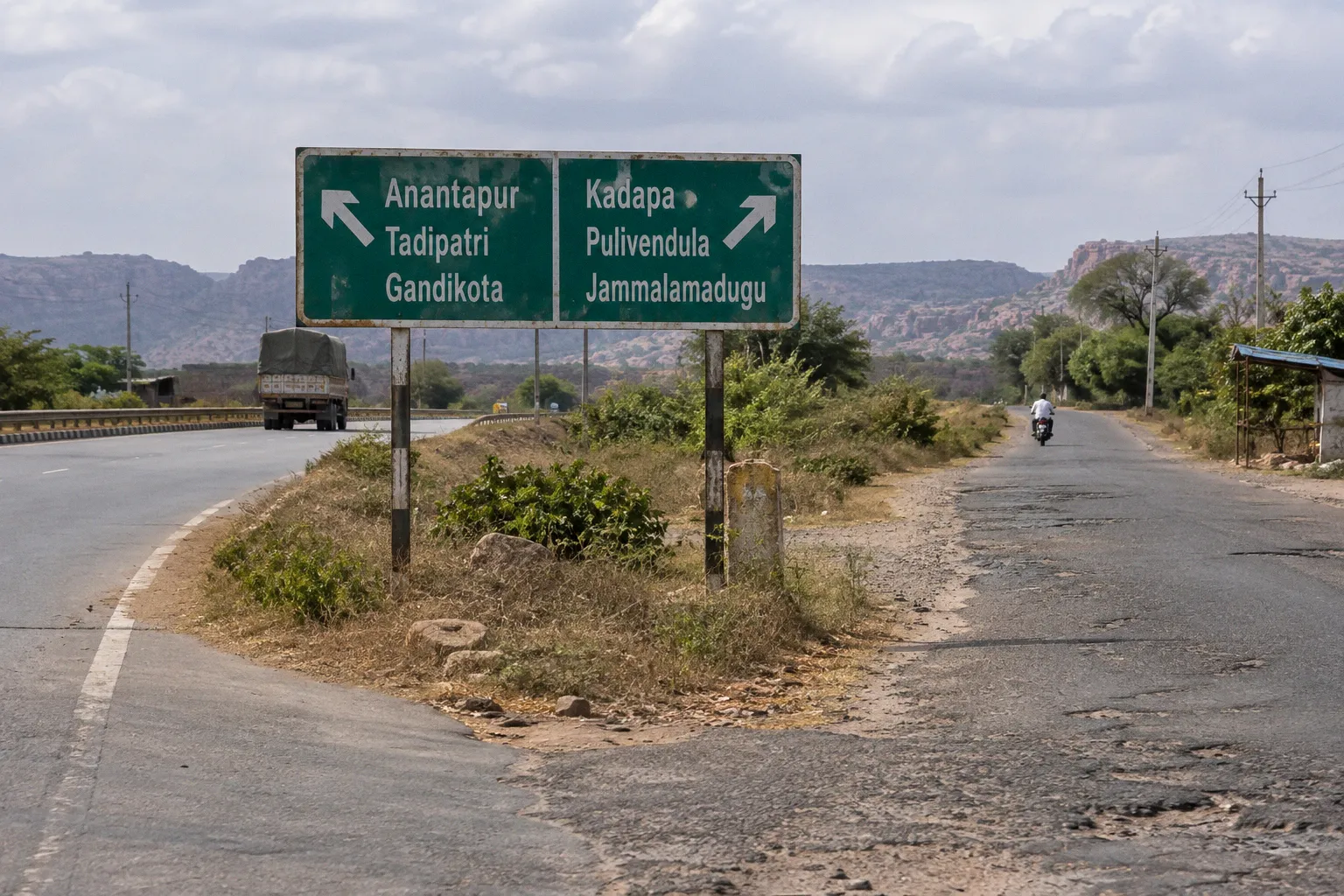
The difference comes from route selection, not from the final approach to the canyon.
You have two practical options. The Anantapur–Tadipatri route uses NH 44 for a longer section and then turns east toward Jammalamadugu and Gandikota. The Kadiri–Pulivendula or Kadapa-side route is shorter, but it relies more heavily on interior state highways, village roads, single-lane sections, and unmarked speed bumps.
For most drivers, the decision is simple: choose Anantapur for road consistency, fuel access, family travel, and a more predictable drive. Choose the shorter interior route only when reducing distance matters more than maintaining highway speed and infrastructure.
The route comparison at a glance
The gandikota route from bangalore via anantapur vs kadapa is not a choice between two equivalent highways. One route trades distance for road quality. The other trades highway comfort for a shorter line across the interior.
| Parameter | Anantapur–Tadipatri route | Kadiri–Pulivendula/Kadapa route |
|---|---|---|
| Approximate total distance | Around 340–350 km, depending on the final connection | Around 280–300 km on the shorter interior alignment |
| Typical driving time | Approximately 6–6.5 hours | Approximately 5.5–6 hours when traffic and road conditions cooperate |
| Main road advantage | Four-lane NH 44 for most of the initial journey | Shorter overall distance |
| Road consistency | Higher. The NH 44 section is generally well maintained and multi-lane | Lower. Expect single-lane stretches, village traffic, and speed breakers |
| Fuel and food access | Better along the main highway corridor | Sparse on some sections; gaps can approach 100 km |
| EV suitability | More practical because of better highway infrastructure | Less predictable on remote interior sections |
| Family suitability | Better for children, older passengers, and large vehicles | Acceptable with planning, but less forgiving if delays occur |
| Belum Caves integration | Convenient to combine with a Tadipatri-side itinerary | Possible, but less direct depending on the selected branch |
| Main operational risk | Longer distance and more total road time | Rural bottlenecks, unmarked bumps, limited services |
The shorter route is not automatically the faster route. A 50–70 km reduction can disappear through village congestion, braking for speed bumps, road works, slow-moving traffic, and stops caused by limited services.
The shortest line to Gandikota is not always the shortest driving day.
The Anantapur–Tadipatri corridor: the default choice for predictable travel
The Anantapur option begins by keeping you on NH 44 for a longer distance. From Bangalore, the broad sequence is NH 44 toward Anantapur, followed by the turn toward Tadipatri, Jammalamadugu, and Gandikota.
This route is roughly 60 km longer than the shorter interior alignment. That extra distance has a function. It keeps the vehicle on a four-lane highway for most of the early and middle part of the drive, where speed, overtaking, lane discipline, and roadside services are easier to manage.
The route is strongest in four situations:
- You are driving a family vehicle with children or older passengers.
- You are using an electric vehicle and need a more serviceable highway corridor.
- You want a lower-risk night or early-morning departure.
- You are combining Gandikota with Belum Caves and want a clean regional itinerary.
The highway section also reduces the number of decisions required from the driver. You spend less time reacting to abrupt village entries, unmarked speed breakers, roadside parking, and narrow passing points. That matters after several hours on the road. Driver fatigue is not solved by a four-lane highway, but it is usually easier to manage than fatigue on a continuous interior-road sequence.
Where the route becomes less predictable
The Anantapur route is not a motorway all the way to the canyon. The final approach after leaving the main highway still requires attention. Road quality becomes more variable as the route transitions toward Tadipatri, Jammalamadugu, and Gandikota.
Do not interpret the NH 44 advantage as permission to maintain highway speed after the turn-off. The operating conditions change:
- Local traffic becomes more prominent.
- Road width may reduce.
- Junctions and village sections require lower speeds.
- Speed breakers may not be marked clearly.
- Fuel and food planning becomes more important after leaving the primary corridor.
The correct driving method is to treat the route as two separate operating environments. Use the highway efficiently, then reset your speed and expectations when entering the interior section.
Belum Caves as a route-planning advantage
Belum Caves is approximately 70 km from Gandikota and is often combined with the same road trip, especially when using the Anantapur and Tadipatri side of the journey.
That combination works best when planned as a regional circuit rather than an improvised detour. The route already takes you toward the Tadipatri side before the final approach to Gandikota. Adding Belum Caves can produce a more efficient itinerary than arranging it as a separate trip from Bangalore.
The constraint is time. Gandikota is not a quick roadside stop from Bangalore. A same-day Bangalore departure, canyon visit, Belum Caves visit, and return drive creates a long exposure period for the driver. If both sites are included, use a planned overnight schedule. Do not depend on the assumption that every stop will take only a few minutes.
The shorter Kadiri–Pulivendula and Kadapa-side routes
The interior route generally runs from NH 44 through Bagepalli or Gorantla, then toward Kadiri, Pulivendula, and Jammalamadugu. Depending on the selected navigation branch, the route may use Muddanur or connect through the Kadapa side.
This is the route to select when the reduced road distance is the primary objective. The total can fall to approximately 280–300 km. Under favorable traffic conditions, the shorter route may produce a shorter elapsed drive. It can also fail to do so.
The main issue is not navigation. It is road behavior.
Interior sections can include:
- Single-lane or narrow two-way stretches.
- Frequent village traffic.
- Unmarked speed bumps.
- Slow agricultural and commercial vehicles.
- Long gaps between fuel stations.
- Limited dining options.
- Sparse roadside support if the vehicle develops a problem.
Some stretches may have as much as 100 km between dependable fuel or dining opportunities. That figure is not a reason to avoid the route. It is a reason to leave Bangalore with the vehicle prepared rather than treating every settlement as guaranteed support.
The speed-breaker problem
Unmarked speed bumps are a more serious planning issue than their size suggests. They force repeated braking, reduce average speed, and increase the chance of suspension impact when approached too quickly. They are also easy to miss in low light or when following another vehicle.
On this route, maintain a speed that allows the vehicle to stop within the visible road distance. Avoid building a schedule around a high average speed. A navigation application may show a short estimated time, but it cannot reliably account for every village obstruction, local diversion, or unmarked bump.
The practical rule is direct:
1. Start with a full or near-full tank.
2. Refuel before entering the longest remote section.
3. Carry drinking water and food that does not require refrigeration.
4. Avoid scheduling the most isolated segment after dark.
5. Treat every village approach as a controlled-speed zone, even when signage is absent.
This is not excessive caution. It is the correct response to a route with lower roadside redundancy.
Fuel, food, and vehicle logistics
The best road route to Gandikota canyon depends partly on the vehicle. A compact petrol car, a diesel SUV, and an electric vehicle do not have the same operating margin on the two corridors.
Fuel planning
On the Anantapur route, NH 44 provides a more dependable sequence of fuel and food stops. That does not remove the need to refuel before the interior turn. It simply gives you more opportunities to correct a poor starting decision.
On the Kadiri or Kadapa-side route, the margin is smaller. Fuel gaps can become long, particularly once you move away from the major highway. Do not wait for the low-fuel warning. Refuel when a reliable station is available and the tank level still gives you a meaningful reserve.
Carry a physical payment option as well as a phone-based payment method. Connectivity and payment reliability can vary outside the main highway corridor. A small cash reserve is operational equipment, not a lifestyle preference.
Food and water
Highway access produces more options, but the final Gandikota approach is not a continuous service zone. Interior roads can have long stretches with sparse dining facilities.
Carry:
- At least one personal water supply for each passenger.
- Additional water for delays and vehicle problems.
- Dry food with a stable shelf life.
- Oral rehydration supplies for hot-weather travel.
- A basic waste bag for keeping the vehicle and roadside clean.
Do not assume that a listed restaurant, fuel station, or roadside shop will be open when you arrive. Navigation databases are useful for route orientation. They are not a guarantee of operating hours or stock.
Electric vehicles
The Anantapur route is the better choice for electric vehicles because the NH 44 corridor offers stronger highway infrastructure and more practical access to services. The interior route may be shorter, but a shorter route with limited charging access is not operationally superior.
Before departure, calculate the route against:
- The vehicle’s realistic highway range.
- Air-conditioning use.
- Passenger and luggage load.
- Temperature conditions.
- The charging options available before leaving NH 44.
- The return-trip requirement.
Do not plan to arrive at Gandikota with the battery nearly depleted unless you have verified the next charging point and the distance to it. Remote-route recovery is slower and more complicated than petrol-station recovery.
Rail and transfer alternatives
Driving is the most flexible way to reach Gandikota from Bangalore, but rail access can reduce the initial road burden.
The nearest major railway station is Kadapa, approximately 80 km from Gandikota. Closer local passenger stations include Jammalamadugu, around 18 km away, and Muddanur, around 30 km away. These are not interchangeable in terms of train frequency, connections, or onward transport availability.
For a rail-based plan, the final road transfer must be arranged before departure. Do not assume that a station close to the canyon will have immediate taxi availability, especially outside normal daytime arrival periods.
The choice between Kadapa and a closer local station is therefore a logistics decision:
- Kadapa: farther from Gandikota but a more significant regional railhead.
- Jammalamadugu: closer to the destination and useful when a suitable passenger connection exists.
- Muddanur: another practical local access point, depending on the train schedule and onward vehicle availability.
A rail itinerary can work well for travelers who do not want to drive 280–350 km. It is less suitable for heavy camping equipment unless the transfer vehicle is already confirmed.
The last 18 km from a railway station can be harder to solve than the first 300 km by road if you arrive without an onward transfer.
Which route should you choose?
Use the following decision sequence instead of selecting the shortest line automatically.
Choose Anantapur–Tadipatri when:
- You want the most consistent road surface and lane capacity for most of the trip.
- You are carrying children, older passengers, or substantial luggage.
- You are driving an electric vehicle.
- You prefer more frequent access to fuel, food, and highway services.
- You are combining Gandikota with Belum Caves.
- You plan to start early but may reach the final approach later than expected.
- You are unfamiliar with the interior roads.
The Anantapur route is the better default for the first visit. Its disadvantage is measurable: more kilometres and usually a longer total drive. Its advantage is operational: fewer sections where a small delay becomes a major schedule problem.
Choose Kadiri–Pulivendula or the Kadapa-side route when:
- Your priority is reducing total distance.
- You are comfortable driving on interior state highways.
- You can leave with adequate fuel, food, water, and vehicle range.
- You are travelling in daylight.
- You have checked recent local conditions before departure.
- You are not relying on frequent services or guaranteed roadside assistance.
The shorter route is more dependent on execution. It rewards preparation and punishes casual planning.
Do not make the choice using distance alone
A navigation application may recommend the shorter interior route because it calculates a lower distance or a marginally lower estimated time. That calculation does not necessarily represent the best travel experience. It may not reflect current surface repairs, local traffic, temporary diversions, monsoon damage, or the practical delay created by unmarked speed bumps.
Real-time road conditions on specific state highway sections can change after monsoon seasons and road repairs. Confirm the final route shortly before departure through current local reports or accommodation operators. Treat any older route description as a planning baseline, not as a live road-status report.
A practical departure sequence from Bangalore
The route decision should be made before loading the vehicle. Use this sequence:
1. Select the corridor. Decide whether the priority is highway consistency or reduced distance.
2. Mark the service break. Identify the last dependable fuel and food opportunity before the longest rural section.
3. Check vehicle range. Include the return leg from Gandikota or the distance to the next verified fuel or charging point.
4. Set a daylight target. Aim to complete the most unfamiliar interior section before dark.
5. Confirm the destination approach. Check the final turn sequence to the accommodation or canyon access point.
6. Carry offline navigation. Download the route before leaving the stronger-connectivity highway.
7. Leave a time buffer. Do not build the day around the shortest displayed navigation estimate.
8. Recheck conditions. Look for recent information on road repairs, flooding, diversions, or local closures before departure.
The route from Bangalore to Gandikota is long enough that a minor planning error can become a fuel issue, a missed meal, or a late arrival on an unfamiliar road. The fix is not complicated. Carry margin.
Final recommendation
For most travelers, take NH 44 toward Anantapur, continue toward Tadipatri and Jammalamadugu, and use the longer corridor to reach Gandikota. It adds distance, but the four-lane highway section provides better road consistency, stronger service access, and a more manageable workload for the driver.
Use the Kadiri–Pulivendula or Kadapa-side route when you have a clear reason to reduce kilometres and are prepared for the trade-off. Expect single-lane sections, village traffic, unmarked speed bumps, and long service gaps. Start with fuel, water, food, and a realistic daylight plan.
Before departure, run this final check:
- Route selected for road conditions, not only distance.
- Fuel level sufficient for the longest remote section.
- EV charging plan verified, if applicable.
- Water and food packed.
- Offline map available.
- Recent road-condition information checked.
- Final approach to Gandikota identified.
- Return or onward transport arranged.
Do not treat Gandikota as a destination reached by simply following the shortest blue line on a map. Select the corridor that matches your vehicle, passengers, range, and tolerance for rural-road uncertainty. For a first visit, the Anantapur route is the controlled option. The interior route is the distance-saving option. Know which one you are choosing before the highway ends.