Owk Reservoir scenic drive: route options for travelers
The main mistake on an Owk Reservoir scenic drive is treating the destination as a single, clearly marked attraction with one obvious approach.
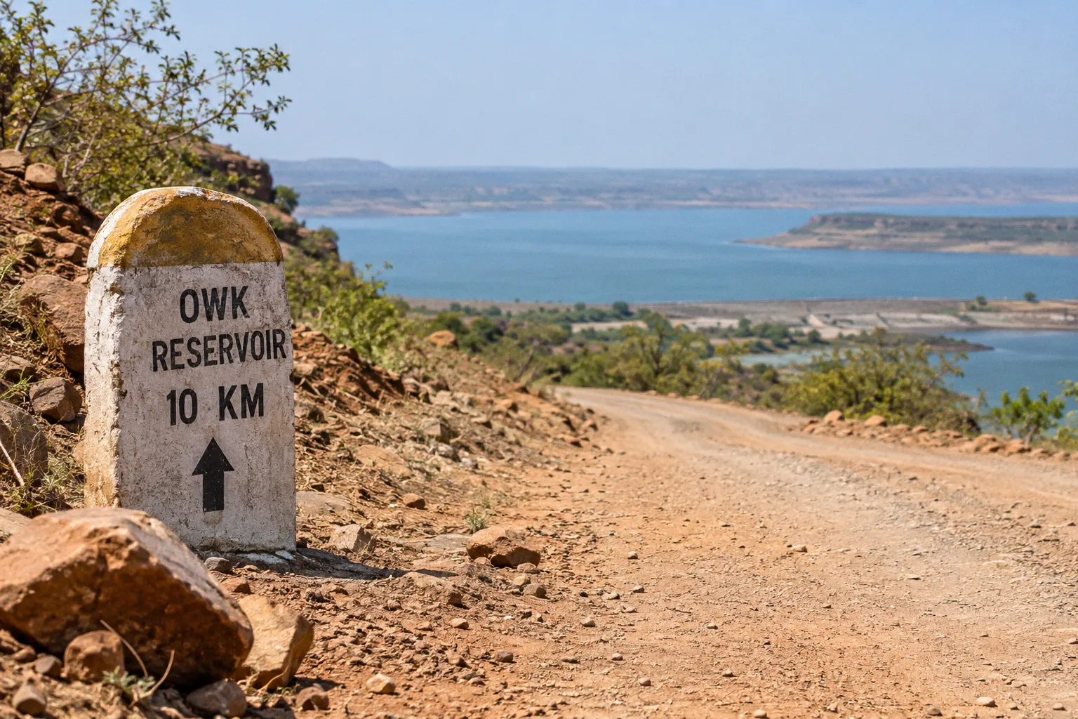
In practice, Owk sits within a wider Rayalaseema landscape of reservoirs, limestone caverns, agricultural roads, and fortified canyon country, so the best route depends on what you want the day to contain: a short water-side detour from Belum Caves, a longer Gandikota excursion, or a broad circuit that adds Yaganti or Mylavaram Dam.
The distances are manageable on paper, but the published driving estimates do not always agree. Gandikota and Belum Caves are listed at roughly 61–62 kilometres apart, while Owk Reservoir is reported as about 10 kilometres from Belum Caves and approximately 70 kilometres from Gandikota. Those figures form a useful planning framework, not a guarantee of arrival time. Road conditions, local access, route selection, and the point at which a map measures each destination can change the practical experience considerably.
Navigating the Gandikota–Belum–Owk triangle
For most independent travelers, the most coherent Owk Reservoir scenic drive route options begin with Gandikota and use Belum Caves as the central handover point. The geography makes sense: Gandikota gives you the Pennar Gorge and fort landscape, Belum introduces a subterranean limestone environment, and Owk shifts the journey back into open water and engineered terrain.
The Government of India's Gandikota tourism master plan places Belum Caves approximately 61.5 kilometres from Gandikota via Tadipatri Road, with an estimated road time of 1 hour 44 minutes. A separate route listing gives a very similar distance, 61.3 kilometres, but estimates the drive at approximately 58 minutes. Neither figure should be treated as the definitive travel time. The discrepancy is itself useful information, because it shows how much route assumptions and traffic conditions can affect a relatively short inter-destination journey.
From Belum Caves, Owk Reservoir is reported as approximately 10 kilometres away. This is the simplest pairing in the area: explore the caves first, then travel a short distance toward the reservoir for an entirely different landscape. It is also the easiest option if your main interest is geological variety rather than covering the greatest possible number of attractions.
The approximate relationships look like this:
| Route segment | Reported distance or estimate | How to use it |
|---|---|---|
| Gandikota to Belum Caves via Tadipatri Road | 61.5 km; about 1 hour 44 minutes in the Government of India master plan | Plan as a substantial transfer, not a quick hop |
| Belum Caves to Gandikota | 61.3 km; about 58 minutes in a separate route listing | Treat the shorter estimate as source-dependent |
| Belum Caves to Owk Reservoir | About 10 km | Natural short extension after the caves |
| Owk Reservoir to Gandikota | About 70 km | Useful for a direct-looking day plan, but verify the actual road route |
| Owk Reservoir to Yaganti | About 34 km | Strong option for extending the circuit east or northeast |
| Owk Reservoir to Jammalamadugu | About 56 km | Useful when connecting the reservoir area with the Pennar-side route network |
The important distinction is between a mapped distance and a comfortable touring route. A road can be short while still requiring slower progress, local navigation, or a pause to confirm where the visitor access actually begins. The available information does not establish a current official scenic-drive route, nor does it reliably confirm road surface, construction, traffic, or night-driving conditions across the full circuit.
Option one: Gandikota to Belum Caves, then Owk
This is the strongest choice when you want three contrasting environments in one outing:
1. Begin at Gandikota, allowing time for the fort precinct, canyon viewpoints, and the routes that run along the Pennar gorge.
2. Travel toward Belum Caves through the Tadipatri Road connection identified in the tourism master plan.
3. Visit the caves before continuing the reported 10-kilometre connection toward Owk Reservoir.
4. Use Owk as the final landscape of the day, when the open water and broad horizon provide a visual release from the enclosed cave passages.
This sequence works spatially as well as photographically. Gandikota is defined by exposed rock, defensive walls, and a deep river-cut gorge. Belum turns the journey inward, beneath the surface. Owk then reopens the view, replacing confined passages with a large reservoir landscape shaped by bunds, catchments, and water-management infrastructure.
It is not a route to rush. If Gandikota is treated as a brief roadside stop, the circuit may fit into a demanding day, but travelers who want to understand each place should consider splitting the journey or starting early. The published estimates for Gandikota and Belum differ by almost an hour, and that difference matters when cave access, daylight, meal stops, and the final approach to the reservoir all compete for the same afternoon.
Option two: Gandikota and Owk as the primary pairing
A reported distance of approximately 70 kilometres places Owk Reservoir within reach of Gandikota without requiring Belum Caves. This is the more focused route for travelers whose priority is the canyon-and-reservoir relationship rather than a full geological circuit.
The route should be planned as a connection between two water landscapes with different physical characters. Gandikota is associated with the Pennar Gorge and the historic settlement above it, while Owk Reservoir is an earthen dam system linked with the Paleru River and related structures. The journey is therefore not simply from one viewpoint to another: it moves from a naturally incised gorge and fortified plateau to a managed reservoir basin.
Because the exact current road conditions and precise scenic access points were not established, we should resist describing every stretch as a designated viewpoint road. The safest planning method is to identify the reservoir destination in your navigation system, then confirm locally where visitors can legally and practically stop, whether boat operations are active, and which approach gives access to the bund or tourism facilities.
This route suits you if:
- Gandikota is the principal destination and Owk is an afternoon extension.
- You prefer open landscapes to cave interiors.
- You want a less crowded, less tightly scheduled day.
- You are carrying your own food and water and are comfortable with facilities that may be limited or variable.
- You are willing to turn the reservoir into a flexible stop rather than a guaranteed package of boating, restaurants, and marked viewpoints.
The most reliable way to plan Owk is to treat it as a landscape, not as a single attraction with a fixed timetable.
What the Owk Reservoir landscape actually offers
Owk Reservoir is described as an earthen dam across the Paleru River in Andhra Pradesh's Kurnool region. The reported system includes the Paleru, Gollaleru, and Thimmaraju Cheruvu structures, with the bund raised to 220 feet and the reservoir covering more than 1,000 acres. These figures help explain why the area feels broader than a small local tank: the experience is shaped by an extensive water-management landscape rather than one isolated embankment.
The reservoir's scale also changes how you should read the road. A scenic drive here is not necessarily a continuous road skirting the water. In many reservoir environments, the most interesting views appear in intervals: a rise in the road reveals the water, a bund or crossing frames the basin, and a turn toward a settlement changes the relationship between open shore, cultivated land, and engineered structure. The journey is therefore about traversing a sequence of visual openings rather than following one officially marked waterfront promenade.
The reported tourism facilities include a boat club, cruise boats, and speed boats, as well as two waterfalls in the catchment area named Gollaleru and Paleru. These details make Owk more than a viewpoint stop, but they should be handled with caution when building a 2026 itinerary. A current official confirmation of operating days, opening hours, ticket prices, and weather-related closures was not established.
Older or recently crawled listings report a cruise-boat fare of INR 150 per person and a speed-boat fare of INR 200 per person, with the speed boat limited to four passengers. These are planning references only, not guaranteed current prices. The same caution applies to reported operating windows of 9:00 AM to 1:30 PM and 2:00 PM to 5:30 PM. Confirm locally before arranging your day around a boat departure, particularly if you are arriving after a cave visit or crossing the region from Gandikota.
The reservoir is best understood through three layers:
- The engineered layer: the earthen bund, water-control structures, and the broad reservoir basin.
- The geological layer: the dry, exposed terrain and rock formations that connect Owk to the wider Rayalaseema landscape.
- The seasonal layer: changing water levels, weather, vegetation, and the possibility that access to boats or catchment features varies across the year.
For photography, the practical question is not simply where the water is, but where the land allows a clean relationship between foreground and horizon. A high point near the approach may show the full basin, while a lower access road may make the bund and shoreline more legible. Since the precise legal roadside viewpoints have not been reliably established, do not assume that every attractive shoulder is suitable for stopping. Use wider pull-offs, avoid blocking local traffic, and ask before entering private or operational areas.
The catchment's two reported waterfalls, Gollaleru and Paleru, are worth treating as conditional features. Waterfall visibility in this kind of terrain depends heavily on recent rainfall and on whether the upstream reservoir is releasing water. A dry-season visit can show you the channels and rock platforms without the falling water, while a post-monsoon visit can change the whole character of the catchment. If the waterfalls matter to your itinerary, build the route around them only after a local check rather than relying on a fixed schedule.
Building a wider circuit with Yaganti
Yaganti is the most natural addition when you want to turn the Owk Reservoir drive into a broader inland excursion. The reservoir is reported as approximately 34 kilometres from Yaganti, making the two destinations close enough to consider within one route plan, although the day becomes more demanding once Gandikota or Belum is included.
A Gandikota–Belum–Owk–Yaganti itinerary can work for travelers who enjoy movement and variety, but it is not automatically the best itinerary for understanding the places. The sequence crosses several distinct environments, and each one rewards time:
- Gandikota requires orientation along the fort and gorge edge.
- Belum Caves involve an underground visit whose pace depends on access and the sections open to visitors.
- Owk is experienced through open distance, water, and the reservoir's structural landscape.
- Yaganti adds a different cultural and architectural emphasis rather than another version of the same scenery.
The temptation is to measure success by the number of pins covered. A better approach is to decide which location gets the most forgiving light and which one can tolerate a shorter visit. If the reservoir is your central subject, place it in the part of the day when you can arrive without rushing from the caves. If Yaganti is essential, consider making it the endpoint of a separate leg rather than squeezing it into the return from Owk.
The available distance figures support a circuit concept, but not a formally designated tourism circuit. We should call it a practical combination of regional stops, not an official branded route. Navigation apps may also select different roads from those assumed by tourism listings, so load the route before leaving a stable-signal area and review the day as a sequence of destination-to-destination legs.
One practical consequence is that the order of stops matters more than the total kilometres covered. Gandikota and Yaganti both reward a slower approach, while Owk and Belum can absorb a more efficient visit. A reasonable ordering might place Gandikota early, Belum in the middle hours when light leaves the surface, and Owk as the closing wide landscape. Yaganti fits either as a separate day or as the final stop of a longer circuit if you are prepared to extend the driving into the late afternoon.
Where Mylavaram Dam fits—and where it does not
Mylavaram Dam belongs to the same larger excursion region but should not be confused with Owk Reservoir. The sources identify Mylavaram as a scenic reservoir on the Pennar River, used for picnics and boating, while Owk is associated with the Paleru-linked reservoir system near Owk. They are separate water bodies with different geographic relationships to Gandikota.
This distinction matters because the two places can look interchangeable in a rushed itinerary: both offer water, open terrain, and the possibility of a quiet stop away from the main heritage sites. Their context is different, however. The Gandikota tourism master plan places Gandikota Dam upstream and Mylavaram Dam downstream on the Penna River, and identifies both as accessible through state highways, district roads, and local roads serving Gandikota and nearby settlements.
Mylavaram is particularly useful when your wider route already includes Kadapa or Jammalamadugu. The official YSR Kadapa district tourism page places Gandikota approximately 77 kilometres from Kadapa and 15 kilometres from Jammalamadugu, while identifying Mylavaram Dam as a picturesque picnic destination. Those figures can help you think in terms of regional gateways rather than a single loop beginning and ending at Gandikota.
A practical division might look like this:
If you are based around Gandikota
Use Owk and Belum for the geological and reservoir-focused circuit, keeping Mylavaram as a separate Pennar-side extension if your schedule allows.
If you are approaching from Kadapa
Mylavaram can fit naturally into the approach or return, while Gandikota remains the principal gorge and heritage stop. Owk may require a separate leg rather than a casual detour.
If you are routing through Jammalamadugu
The 15-kilometre relationship between Gandikota and Jammalamadugu makes the town a useful orientation point, but the available research does not establish current fuel, food, signal, or transport reliability along every connecting road. Treat it as a geographic reference, not a guarantee of services.
Owk Reservoir and Mylavaram Dam belong on the same regional map, but not in the same mental box: one is a Paleru-linked reservoir near Owk, the other a Pennar-side destination downstream from Gandikota.
On-the-road logistics for the Owk Reservoir route
The route is straightforward to imagine and less straightforward to schedule because several practical details remain variable. Current road conditions, construction, traffic levels, fuel stations, restaurants, emergency services, and mobile-signal gaps along the complete circuit were not reliably established. That does not make the journey impractical; it means the itinerary should leave room for local confirmation.
Before setting out, divide the day into legs rather than relying on one total travel time:
1. Gandikota to Belum Caves: use the Tadipatri Road connection as the planning reference, but allow more time than the shortest online estimate suggests.
2. Belum Caves to Owk Reservoir: the reported distance is about 10 kilometres, yet the actual arrival point and visitor access should be confirmed locally.
3. Owk to Yaganti, if added: plan this as a distinct transfer, using the reported 34-kilometre relationship only as an approximate guide.
4. Owk or Yaganti back toward Gandikota, Kadapa, or Jammalamadugu: verify the return route before leaving the reservoir area, especially if you expect to travel after sunset.
A few habits make the circuit more resilient:
- Download or save the route before departure instead of depending entirely on mobile data.
- Carry drinking water and food that does not require a confirmed restaurant stop.
- Ask locally whether boating is operating on the day of arrival, and whether tickets, passenger limits, or time windows have changed.
- Avoid planning the final reservoir approach in darkness when the road and roadside stopping conditions are unfamiliar.
- Keep the vehicle fuelled before entering a longer rural leg; the full circuit's service points have not been reliably confirmed.
- Allow time for the route itself, not just the attractions, because the visual character of the drive is built from the transitions between settlements, catchments, and water bodies rather than from a single viewpoint.
The best Owk Reservoir scenic drive is the one built around honesty about what is known and what is not. Distances, bund dimensions, and waterfall names can be planned in advance; current boat operations, ticket prices, viewpoint access, and roadside services cannot. Travelers who separate these two categories will spend less time improvising at the gate and more time actually looking at the landscape they came to see.