Mylavaram Dam excursion: essential preparation and local access
The most common navigational mistake at Gandikota is treating Mylavaram Dam as a brief detour rather than its own half-day commitment.
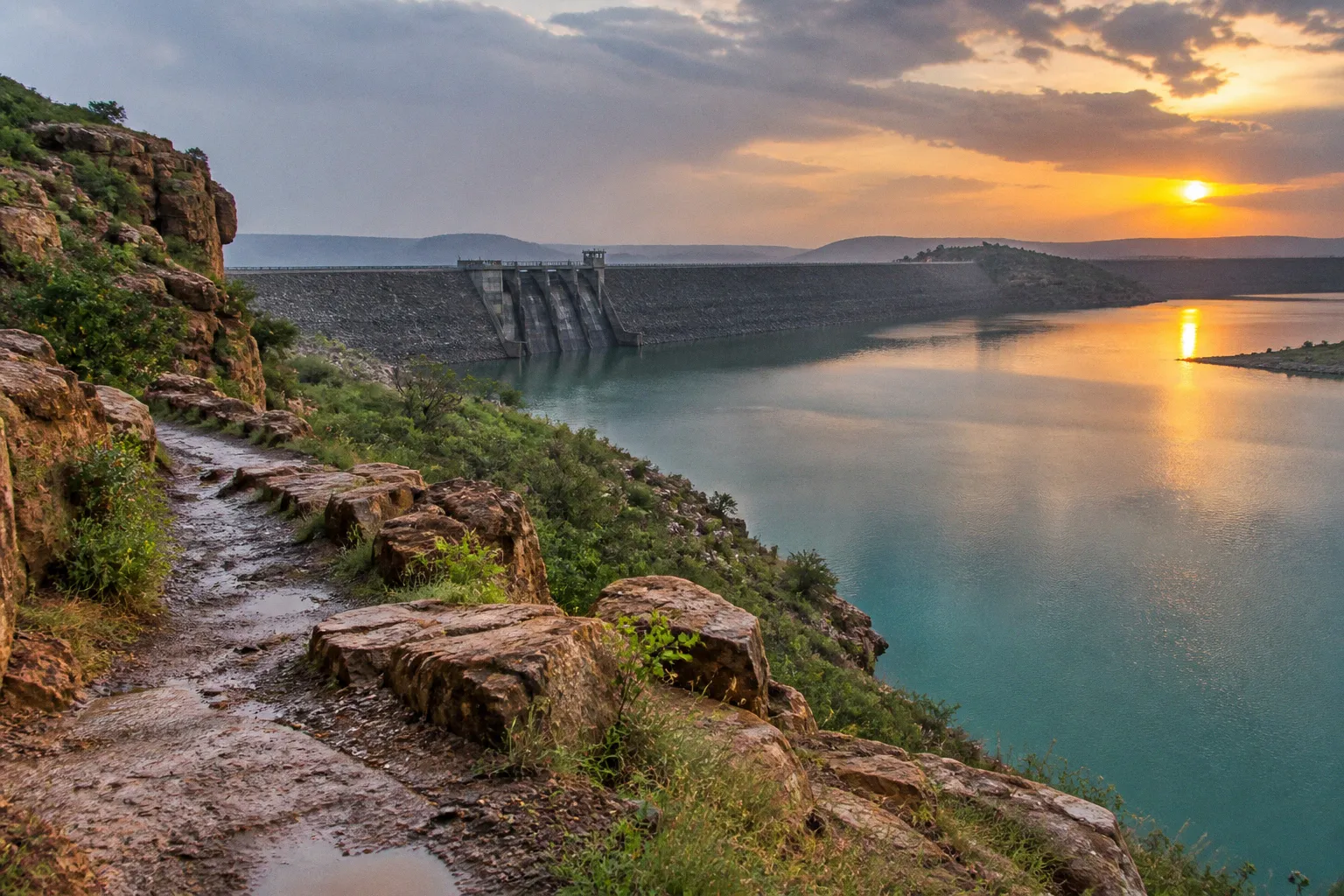
Travelers arrive at the canyon rim at sunrise, walk the fortifications, watch the Penna River cut through the gorge, and then, if the light is right, drive southeast toward the reservoir expecting a fifteen-minute stop. What they find instead is a working irrigation project spread across a wide, flat stretch of the same river valley, along with a backwater zone operated by AP Tourism where boats generally begin running at 9:00 AM.
The “quick stop” mindset is exactly what costs visitors the kayaking window, the sunset reflection on the water, and a proper understanding of the dam as an engineered landscape. Mylavaram deserves the same structural attention as the canyon above it, just approached with a different logistical map. Planning the route, confirming local access and boating arrangements, and leaving enough time for the return drive are more important here than squeezing in one more viewpoint.
Logistics and transit: reaching the reservoir from Gandikota
The route out of Gandikota toward Mylavaram begins where most travelers are already standing: the road that flanks the gorge’s eastern lip and loops back toward the village of Jammalamadugu. From the fort parking area, you descend through the small settlement near the canyon mouth and join the secondary road that runs parallel to the Penna River’s southern bank.
The total distance is roughly ten kilometers, which sounds modest on paper but unfolds more slowly than the odometer suggests. The road threads between fields, irrigation channels, and occasional stretches where monsoon runoff has reclaimed the shoulder. Allow roughly thirty to forty minutes for the drive in a hired jeep or car, and closer to an hour if you are on a two-wheeler, particularly when livestock, tractors, or rough road edges slow the journey.
Public transit is the variable worth treating cautiously. Buses do run between Jammalamadugu and the dam vicinity, but they do not generally pull up onto the dam structure itself, and their frequency becomes less useful outside the morning period. For most independent travelers, the more dependable approach is to negotiate a return trip with a local driver in Gandikota before setting out.
Ask specifically whether the fare includes waiting time at the reservoir. The boating counter and the dam crest are not necessarily in the same place, and walking between them along the embankment road adds distance that catches people off guard. A driver who is prepared to wait is more useful than a cheaper one who assumes the trip will be a quick drop-off and pickup.
The road between Gandikota and Mylavaram is shorter than it feels — the river valley flattens out into agricultural plain, and the visual change can throw off your sense of timing.
If you are cycling, the run is relatively flat, scenic, and lined with cotton and groundnut fields for much of its length. The return leg, however, climbs gently back toward the plateau edge near Gandikota village. That final rise is not dramatic, but it feels different after a day in the exposed sun. Start early, carry enough water, and avoid treating the distance as a casual midday ride.
The road conditions can also change with the season. In the dry months, dust and glare are the main irritations. During and immediately after heavy rain, runoff, mud, and damaged shoulders can make the same route slower and less comfortable. A vehicle with a little clearance is preferable if the weather has been unsettled, while two-wheelers require more caution on the unpaved edges and around agricultural traffic.
Navigating the Tatireddy Narasimha Reddy project landscape
Mylavaram is officially the Tatireddy Narasimha Reddy Reservoir, and understanding that name is the first step in reading the place as more than a long earthen mound. The structure is a medium irrigation project built across the Penna River, completed in the early 1980s, with its main canals finished by 1981–82 and the distributary system following a few years later.
The numbers are useful because they indicate what kind of engineering you are standing in front of. The reservoir’s gross storage capacity is roughly 9.96 TMC — thousand million cubic feet — representing the volume held behind the embankment when the gates are closed and seasonal inflows have replenished the basin. The irrigation system was built to serve about 75,000 acres, divided between two main canals: the MR South Canal, with a command area of about 25,000 acres, and the MR North Canal, serving a larger area of roughly 50,000 acres on the other side of the river.
This changes the way the landscape should be read. Mylavaram is not a decorative lake placed beside a sightseeing road. It is the head of a working distribution network. The visual clues are clear once you know what to look for: canal offtake structures, sluice gates, straight embankment lines, access roads, and the broad storage basin behind the dam.
Walking along an accessible section of the crest can be the most clarifying part of the excursion. The geometry suddenly makes sense: the river on one side, the stored water on the other, and the engineered slope between them holding the difference in water level. Access to the embankment proper can vary, however. Confirm locally on the day whether visitors may walk along a particular stretch, and follow any instructions from staff or security. There is no single published permit process that reliably settles every access question in advance.
A dam is a sentence written in earth and water: the river says what it wants to do, and the engineer writes back with a slope, a gate, and a canal.
The viewpoints most likely to remain accessible despite seasonal or administrative changes are the public areas along the approach road. These pull-offs and open stretches allow you to see the water spreading across the backwater basin, with the rocky canyon rim of Gandikota sometimes visible on the horizon to the northwest.
This is where the regional geography clicks into place. The same Penna River that carved the gorge above has been gathered into a wide, still sheet of water below. The canyon and reservoir are not separate attractions connected only by a road; they are two different expressions of the same river system. From the dam side, the spectacular vertical walls of Gandikota become a distant geographical reference rather than the immediate subject of the view.
Do not assume that every attractive-looking track beside the reservoir is a public viewpoint. Some roads lead toward operational areas, canal infrastructure, agricultural land, or private access points. If a gate is closed or a route is not clearly intended for visitors, turn back rather than attempting to find a more adventurous way through. The dam is a working project, and the absence of a sign does not automatically mean unrestricted access.
Water-based recreation: boating and kayaking in the backwaters
The recreational side of Mylavaram is concentrated on the reservoir’s backwater stretch, where AP Tourism operates a boat club with speed boats and kayaks. This is the part of the excursion with the clearest operating window: the boating counter generally opens at 9:00 AM and closes at 6:00 PM. Conditions are usually more comfortable for paddling and photography between mid-morning and the hour or so before sunset, although actual operations can depend on weather, water conditions, staffing, and local decisions.
Standard pricing is in the region of Rs. 200 per person for basic speed boat rides and kayaking sessions. Treat that figure as a planning guide rather than a guaranteed current tariff. Confirm the day’s price, availability, and queue arrangements at the counter before committing the rest of your itinerary to a particular departure time.
Kayaking is where Mylavaram quietly distinguishes itself from the canyon above. The gorge offers vertical drama but no comparable paddling environment; the reservoir offers calm, open water that responds to the slightest stroke and lets you move through a landscape that is half geological, half agricultural.
A kayak suits travelers who want to experience the scale of the backwater basin at a slower pace and observe the shoreline vegetation around the inflow channels. The speed boat is more practical for groups, families, or anyone working with limited time. It covers more distance in a shorter window and gives you a broad sense of the reservoir’s layout before you choose a viewpoint on land.
The experience is not a wilderness expedition, but it still rewards basic preparation. A few details are easy to overlook:
- Arrive earlier rather than later on weekends and local holidays. Kayaks may be assigned on a first-come basis, and the waiting line can become less convenient as the morning progresses.
- Use sunscreen and cover exposed skin. The glare off the water is strong even in the cooler months, and shade becomes limited once you move away from the counter.
- Carry a dry bag or another secure waterproof pouch for your phone, camera, and vehicle keys. Changing facilities at the boating area may be minimal.
- Bring drinking water. Small stalls may be available, but reliable refill points should not be assumed once you are away from the main visitor area.
- Wear footwear that can tolerate dust, wet boarding areas, and uneven ground. Delicate sandals are a poor match for a site that combines a rough approach road with water access.
- Keep your belongings compact. A crowded kayak is less comfortable and makes it harder to protect cameras and phones from splashes.
The boat ride should not be confused with unrestricted access to the reservoir. The operating zone, boarding point, and approved routes are determined locally. Stay within the area indicated by the boat staff and do not treat a quiet stretch of shoreline as an invitation to land or explore independently.
Optimizing your visit: timing and local access requirements
The best time for a Mylavaram Dam excursion is, in practical terms, the cooler dry window from late October through February. The reservoir is often at or near its seasonal high during this period, and the light on the water is softer than during the harshest part of the summer. It is also easier to combine the reservoir with Gandikota when the road, viewpoints, and open areas are less punishing during the middle of the day.
Summer is brutally hot across this part of Rayalaseema. The same exposed plain that makes the reservoir visible also makes it unforgiving between noon and 4:00 PM. If your Gandikota trip is fixed in summer, treat Mylavaram as an early-morning or late-afternoon commitment and avoid building the main walking portion around the midday heat.
The monsoon period can produce the most dramatic water levels and skies, but it also introduces uncertainty. Heavy rain may slow the approach, soften road shoulders, or affect boating operations. The reservoir can look impressive after rainfall, but a spectacular view is not a reason to ignore slippery ground, fast-changing weather, or a temporary closure.
Sequencing matters as much as season. A clean itinerary is to arrive at the reservoir around 9:30 AM, spend an hour on a kayak or speed boat, walk the accessible viewpoints along the southern approach road, and then take lunch near the boating area before returning to Gandikota in the afternoon. This leaves enough time to see the canyon in later light without turning the return journey into a night drive.
Reversing the order, with the dam visit pushed into late afternoon, can work, but it requires more discipline. The road between Mylavaram and Gandikota is not a route to rush after dark. It is unlit in places, and agricultural traffic, livestock, dogs, and other road hazards become harder to read as visibility drops. If you are relying on a hired driver, agree on the departure time before leaving Gandikota rather than trying to arrange the return after the boating session has ended.
Local access requirements are best handled as a same-day confirmation rather than assumed from an old itinerary. Before entering the boating area, check:
- Whether kayaking and speed boat rides are operating that day.
- The current opening and closing time.
- Whether the dam crest or a particular embankment section is open to visitors.
- Whether photography is restricted around operational structures.
- Whether weather or water conditions have changed the available boat routes.
- Where visitors are expected to park and which roads are private or operational.
The question of swimming needs the same careful treatment. Current swimming rules and permissions at Mylavaram are not sufficiently clear to present a simple public-access answer. The backwater zone is organized around boating, not around a formally described swimming facility, and a visitor should not assume that calm-looking water is approved for bathing or recreational entry.
Confirm the local position with the boat operator, site staff, or relevant authority before entering the reservoir for any reason beyond an authorized boating activity. If permission is unclear, do not enter the water. That caution is not just administrative: reservoirs contain changing depths, submerged structures, soft margins, boat traffic, and currents that are difficult to judge from the bank. The sensible default is to look at the water, paddle only through an authorized activity, and leave swimming out of the plan unless local officials clearly confirm that it is allowed and safe.
| Parameter | Mylavaram Dam detail |
|---|---|
| Distance from Gandikota Fort | Approximately 10 km via the Jammalamadugu road |
| Official name | Tatireddy Narasimha Reddy Reservoir |
| River | Penna River basin |
| Dam type | Earthen, medium irrigation project |
| Gross storage capacity | Approximately 9.96 TMC |
| Irrigation coverage | Approximately 75,000 acres in total |
| South Canal command area | Approximately 25,000 acres |
| North Canal command area | Approximately 50,000 acres |
| Boat club hours | Generally 9:00 AM–6:00 PM |
| Speed boat and kayak pricing | Around Rs. 200 per person as a planning estimate |
| Best season | Late October through February |
The dam rewards patience over ambition: visitors who arrive early, confirm the local rules, and stay for the changing light usually get a better Mylavaram than those trying to fit it between two canyon viewpoints.
Building Mylavaram into a wider route
If you are building Mylavaram into a broader Rayalaseema circuit — pairing it with Belum Caves to the north or extending west toward Kurnool — the dam works well as a mid-route anchor. It sits close enough to Gandikota and the Jammalamadugu road network to be practical, but it still demands more time than a quick photograph from the roadside.
Trying to combine Gandikota, Mylavaram, and Belum in a single long day usually turns the itinerary into a sequence of hurried arrivals and departures. The problem is not only the driving distance. Gandikota requires time for the fort, canyon viewpoints, and walking routes; Mylavaram works best when you allow for boating, local access checks, and a slower look at the reservoir landscape; Belum Caves is a separate experience altogether.
Spreading the route across two days gives each place more breathing room. Mylavaram can serve as an afternoon or early-evening stop after Gandikota, provided you have confirmed the return route and are not depending on a late boating session. Alternatively, it can be the first substantial stop of the day, leaving the canyon for later light. The right sequence depends on the season, the boat club’s operating status, and whether your priority is kayaking, photography, or simply understanding the relationship between the gorge and the reservoir.
The ten kilometers between Gandikota and Mylavaram is the easiest part of the planning once you stop treating it as a minor detour. Arrange transport, leave room for waiting time, confirm access locally, and keep the water-based activities within the area and rules set by the operators. After that, the route becomes straightforward enough to let the landscape take over: the canyon narrows the river into drama, while Mylavaram opens it back into scale, irrigation, and still water.